Commoning as a practice of emergency and desire: Reclaiming spatial commons in the neoliberal city
Dagmar Pelger is trained as an architect and works in the academic field next to her practice. For the last few years, she has worked for the Chair for Urban Design and Urbanization (CUD) at the TU Berlin1, and is also part of the Berlin-based architecture cooperative coopdisco.2 Her work focuses on urban commoning practices, spatial commons, and common-good oriented city development which actively includes civil society. We met on Skype during the first lockdown in April 2020 to talk about her practices, teaching, and perspectives in relation to spatial commons in the urban and rural context.
You said you are teaching at the architecture department – I would be curious to learn more about the projects that you do with the students, for example the one in Wrangelkiez. What is your teaching approach and how do you engage with the neighbourhood?
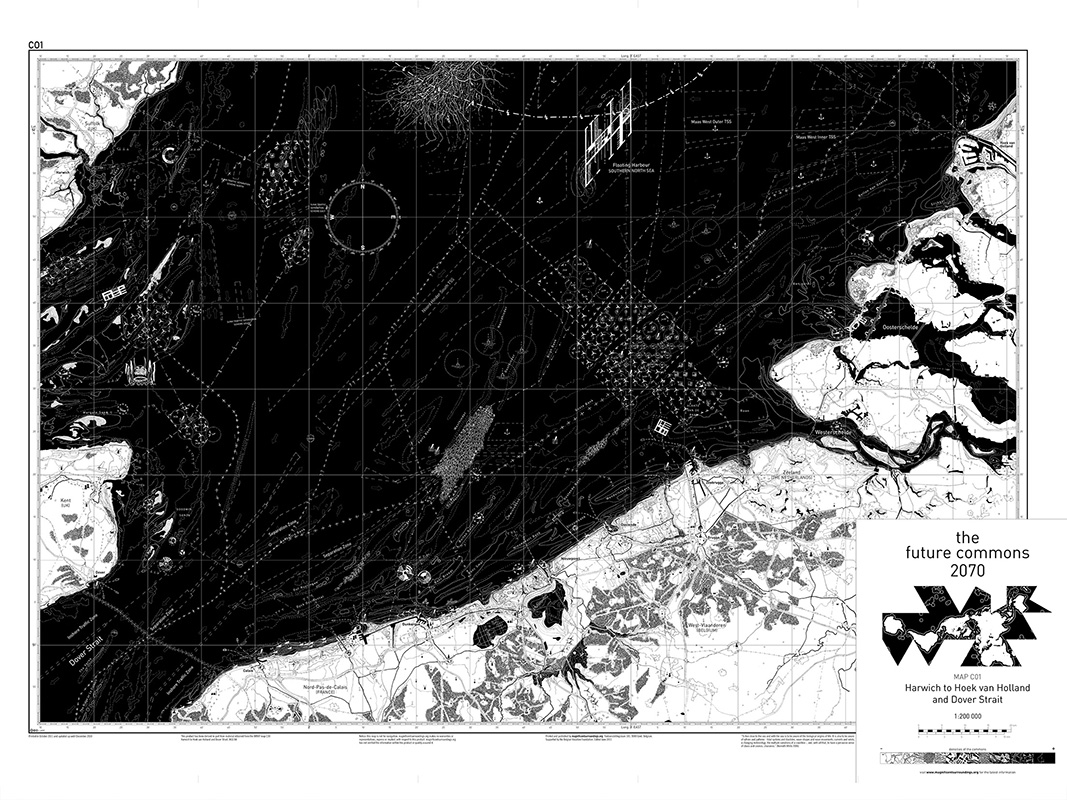
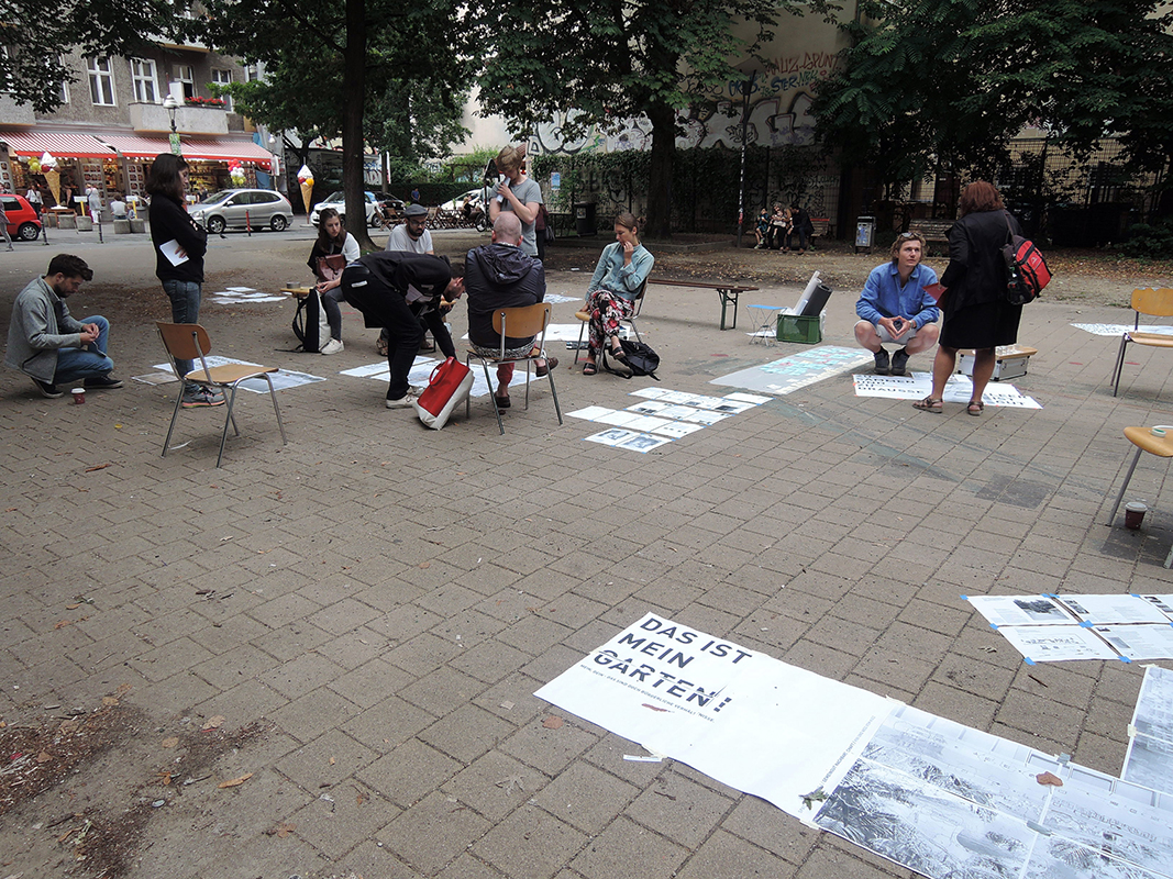
I started to work at the CUD with Jörg Stollmann around 7 years ago. One of his assistants, Matthias Heyden, was doing a reading seminar called ‘Spatial Commons’, where he looked specifically at Tempelhofer Feld, as he was intrigued by the collective gardening practice on it, the Allmende Kontor (Allmende is the german word for Commons). Doing so, he introduced the theme of the commons at the CUD. Inspired by this theme of the “Spatial Commons”, I started a mapping seminar at the CUD. The notion of the commons was familiar since I joined a research project in Brussels together with my office partner Esther Goris, commissioned by Charlotte Geldof. We assisted Charlotte in drawing a map on future marine commons in the year 2070. So somehow, I combined the ideas of Matthias Heyden about “Spatial Commons” with my experience from this mapping research we did earlier in Brussels. That’s how a series of mapping experiments got started. The first seminar I did by myself with twelve students, later joined by my colleague Anna Heilgemeir. Anna, who is involved in urban political initiatives in Berlin, introduced a very cooperative approach, and that’s how we started working also on the neighbourhood in Wrangelkiez. It became one of the larger teaching-based research initiatives at the chair and the base for my PhD.
You collaborated with a neighbourhood centre, the Familien- und Nachbarschaftszentrum Wrangelkiez – was that a collaboration that came into being because of your colleague, Anna, or did you get in touch with them?
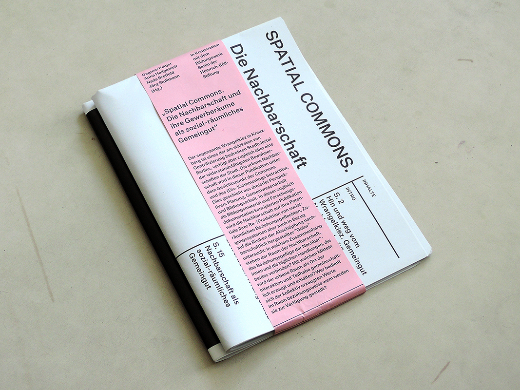
She made the contact – Anna is actually also living there. But the interesting thing is that we simply jumped into this neighbourhood without too much preparation. Because the rents were exploding along Görlitzer Straße, we wanted to understand what was going on. In 2016 already, we came up with this idea to make a seminar called ‘Hin und Weg vom Kiez’ (“Blown away by the Kiez”) with all the connected issues: gentrification, displacement, financialization. We started mapping with the students by spending one week on site in the neighbourhood. We knew about Bizim Kiez3, but had no contact with them. After this first, very academic approach in Wrangelkiez, we decided to redo the seminar in the following summer. When we exhibited our first results at the Nachbarschaftszentrum in Wrangelkiez, where we could use a working space with the students, the initiative Bizim Kiez and the social work within the Nachbarschaftshaus became attentive of our work. We started to have meetings with them. They were very interested in mapping tools and asked us to put a stronger focus on the issue of local commerce. The whole neighbourhood was very concerned with displaced local businesses and shops. Thus, one year later, we collaborated with the initiative Bizim Kiez, which founded a working group ‘Milieuschutz Plus’ for the rental protection for local shops, and, additionally, with the Alice-Salomon-Hochschule (ASH). We decided to draw one collective map with all the students instead of several ones like we did in the first year. This mapping became the basis for an Atlas der Nachbarschaften4, which was then given back to the neighbourhood as a tool of argumentation, communication, and, in the best case, emancipation for the local shop initiatives.
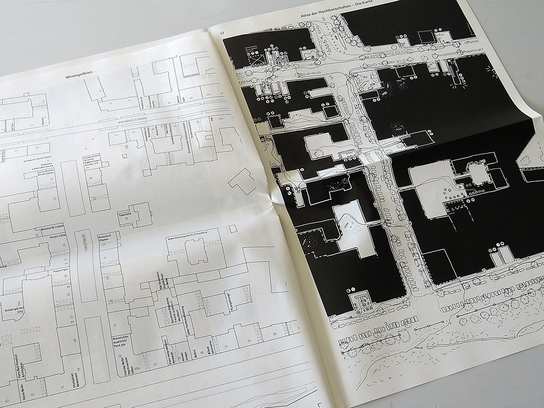
What exactly happened during this mapping: what is on the map and how can it be used as a tool?
The map for us was less a tool of an inventory of all the shops in the neighbourhood; for us, it was more a tool of interpreting the existent neighbourhood spaces along the streets, in the sense of: which shops could be understood as a spatial commons? Could we describe certain shops as relevant common spaces for the neighbourhood in which liveliness, social solidarity, local embeddedness, a feeling of home in the neighbourhood are being produced and maintained by the neighbours? And, could we also identify categories of shops which are not adding value to the neighbourhood but rather absorb the products of the neighbourhood and the spatial qualities I just mentioned? We decided to draw a kind of Nolli-map of the neighbourhood, or rather, a neo-Nolli-map, as we called it. On that map we simply distinguished between those shops as open spaces along the streets, which are relevant, maintaining, and co-productive for the neighbourhood, and those shops as open spaces along the streets which we considered absorbing the values of the neighbourhood. The latter we simply did not draw as open spaces, but included them into the black surfaces of the “private” building blocks.
What are examples for that?
For example around Schlesisches Tor, you find a very dense allocation of shops which really seem to ‘swollow’ the neighbourhood space – you might summarise them under the term ‘touristification’. We drew them with black teeth standing into the wide open street. They attract the tourists, they are there to sell a lot of food in a short time and they bring the neighbourhood space out of balance. This is connected to noise production, to the commodification of the pathways through privatization and leads to an increase of the price level of food as well as of commercial rents. We introduced the notion of ‘Gewerberäume’, which does not only mean shops and businesses, but also social institutions, like kindergardens, places for the elderly, coffee houses for men, safe spaces for young girls and such. So our two poles were local services in the broadest sense on the one hand, and commercial services with a commodifying effect on the other side.
Thus, mainly places that are inside on the ground floor of the apartment buildings – or were you also looking at outdoor spaces?
The Nolli-map concept we used was developed by the Italian architect Giambattista Nolli in the 17th century in Rome, where he drew a floor plan of the city with built space as black surfaces and the non-built space as white surfaces. What we were missing in his drawing, and what we thought we could add to this concept of mapping, was the social layer of action which was not included on his plan. What is exciting about his plan is that church interiors, for example, are drawn as white open spaces just like gardens, streets, and courtyards. So he makes a distinction between built and unbuilt space – but also unbuilt space within built space. By transferring this idea of drawing onto the streets in Wrangelkiez, we drew everything in black which is not accessible for the neighbourhood, and we kept everything white which is accessible. So, let’s say, the bakery around the corner is a white open space, the touristic restaurant is a black space because it doesn’t add any space to the neighbourhood, there is no reason to go there. Even more, those places generate a lot of noise, they occupy the outside even more than the inside space, they appear as obstacles in daily street life and function as a door opener for new investments in touristic programs, while the bakery around the corner allows consumption free access and daily exchange between neighbours and visitors – even space for discussion and difference.
How did the collaboration between architecture and social practice students come into being and how did they work together?
That was very interesting for us. We were missing exactly this kind of expertise in the first seminar. When we did the first mapping at the CUD with architecture students, we realised that we have to include the users view onto the neighbourhood to be able to draw an appropriate map of the urban space – the users of that space are the ones who produce it in the end, day by day. In our first mapping seminar in Wrangelkiez, we simply observed the users of the neighbourhood, we had talks and little interviews, but without any expertise. Through the collaboration with Nada Bretfeld, who is a social worker at the Familien- und Nachbarschaftszentrum and also an assistant for social practice at the Alice-Salomon-Hochschule, we could develop a more integrative methodology between mapping and interviews, merging those two perspectives: the architectural perspective, observations of space, and the social practice perspective of how to include and introduce the observations of users, of passersby, of people active in the neighbourhood. Bringing those two perspectives together was very important for us.
What are the challenges and opportunities of working with real urban issues together with students? Is there anything you ran into?
It is getting more and more common in architecture and urban design studies to leave the school and to look at what is out there. Field work is not necessarily a given in the architecture education, it is still much more a discipline of social studies, maybe sometimes in human geography, and of course in ethnography and anthropology. But these research fields or practices are starting to influence each other. What is a very important motivation for us to leave the school and organise a mapping camp in a real urban condition, and to confront the sphere of the academic teaching world and the one outside in the city, is that it informs the study results in a completely different way. The study is not reduced any more to the physical appearance of buildings, streets, infrastructure, mobile or immobile objects out there, but the students have to integrate their actions in the actual inhabitance of the city. Thus, the spatial analysis becomes a socio-spatial analysis. We consider this not common sense in the spatial disciplines, but at the CUD, the socio-spatial construction of the urban condition is something very essential to understand, as two layers which you can’t separate from each other.
You worked on a publication in 2017 called ‘Spatial Commons’, which nicely connects to some of the things you just talked about. What is your definition of spatial commons and why do you think they are important?
For me, to start working not only on commons, but spatial commons specifically, was motivated by extending the architectural perspective onto urban space production. The commons are explored a lot on a geographical and a juridical, organisational level, or in political, economic and social science – but what I think makes the study of commons on an architectural level very relevant are the consequences it could and should have for architecture and urban design as a discipline. That’s why we focussed on the term of ‘spatial commons’ with regards to questions such as: are there certain spatial conditions which help the commons to emerge? Are there concrete spatial results, some kind of socio-spatial products, if there is a collectivising process of commoning going on? And, really important for us: can you differentiate between commons and non-commons; is there something like commoning and ‘dis-commoning’, and can it be grasped on a spatial level? As an architect and designer, I think you actually have to first understand what is going on within existing urban situations in order to be able to act within these social, economic, and political conditions on the level of design. Mapping was a first attempt to understand what was going on.
How do you see spatial commons emerging and being threatened in cities like Berlin?
Theory says that the commons always emerge and that they are always threatened. Historians, philosophers, and sociologists think that commoning is something which is always ongoing, like, for example, Peter Linebaugh – on the other hand, enclosure is also always ongoing. So you could assume that it is the same case in Berlin: commons are constantly emerging and being threatened again. What I find is peculiar and intriguing about their emergence and enclosure in Berlin is the accelerated history of Berlin of the last 30 years. I think in other metropoles, you have a history of enclosure and re-appropriation of the commons – let’s take London, Sao Paolo, New York, it doesn’t really matter – which are being financialised and commodified within the late capitalist system since the beginning of the 70s and since the years of the 2000s, we have the emergence of finance capitalism coming up. All these big geopolitical and geo-economic changes affected Berlin in a smaller period of time, due to the separation of the two Germanies. Berlin has a twin history: on one hand, it has a history of a capitalist city, but slowed-down due to the walled status of West-Berlin as an island, and on the other hand, it has a history of an East-European communist city, East-Berlin, development with large communal housing estates. After 1990, those two worlds merged into one city government, so what happened between 1970 and 2020 in 50 years in other cities in the world, took place in the last 20-30 years in Berlin. I think that the emergence of commons in Berlin is also – but not only, of course – a direct result of the rapid and massive enclosures of commons in the 90s.
That’s a fascinating analysis! You were also involving mapping in the publication, where you looked at different locations in Kreuzberg – could you tell me a bit more about that?
The ‘Open Spaces’ analysis was the very first seminar I did. What intrigued me was that I didn’t really understand how all the different notions of commons came together: the political, the geographical, the historical, and so on. There was also a personal experience of mine, that was my father telling of a common land which was still used in his childhood in Transylvania. Of course, he didn’t talk about common land – he talked about Allmende and Hutweide, he used German words. Somehow, I understood that they were connected, the childhood memories of my father of rural East-European villages in the 50s and 60s, and this very contemporary notion of the urban commons currently being discussed. For me, that was the reason to compare those two fields of research: the historical view of traditional commons – common lands which were enclosed with the rise of capitalism, which are in some areas still institutionalized, like in Great Britain and Italy – and this very political notion of the commons, inspired by the right to the city movement and discourse. I wanted to understand what those two fields have in common.
That’s why we mapped six open spaces in Kreuzberg. At that time, Kreuzberg was starting to become more active concerning its city planning. There are a lot of political reasons; public land could not be sold any more, so there was a political paradigm shift after 2014. All of a sudden, the planning department became alert of their spaces. We analysed six squares and park-like situations along the Landwehrkanal, including Mehringplatz, Wassertorplatz, Urbanhafen, and Flaschenhalspark. We looked at them as if they were commons: what kind of distinguishing criteria could we find to define them as such and not purely as public or privatized spaces? What is this third spatial category of joint use, not controlled or controllable by the public authorities, but also not private? That’s how these maps came into being. Students worked on them in teams of two, discussing their observations and marking those areas within the open spaces on their map which they considered as being collectivised in the sense of commoning. We compared those squares, parks, and the commoning processes we identified within with functionings of traditional common lands, in order to somehow make a connection between an agricultural world of a collectivised economy, and the modern urban world of a collectivised social economy.
I was wondering how you conducted your research into the historical types of commons, as a lot of times, when people talk about spatial commons and the enclosure movement, then it is looking at England. I was pleasantly surprised to see an analysis of historical types of commons that you can find in the German-speaking context. I am curious how specific this is to this context, or the European one, with the commons being a rather Euro-centric concept. What is your position to this?
The concept of the commons can be found all over the world. But for me the structure of the villages in Transylvania was peculiar: the Anger, the village green, occurred in almost each village. I first rediscovered this village green in Belgium, where you can find a similar type, the ‘dries’, which is also in the middle of the village. I rediscovered it again when I came to Berlin in Brandenburg, and in Poland, so I recognised a certain typology of common land. When I started to look at commons and compared them with the traditional theories about it, I realised that there is a spatial connection between certain types of common spaces and this abstract socio-political concept of commoning in contemporary theories. And then, when I went further, I realised this typology of the village green became some kind of key image for me, because it is really part of my personal perception of the context in which I have spent time.
That was my starting point. Since I didn’t know much more about it, I decided to ask students to do some more research into those traditional types. Together, we realised that the Anger, the village green, is actually a later version of the spatialisation of the common, whereas the earliest one would be the Alb, where people would leave the village to go up the mountain to a completely exterritorial site of collective ownership to graze their cows up there and make cheese. In between, you find the Hutweide, which is just a pasture, an area you can hardly detect because it is often just a lawn somewhere between the fields, so it doesn’t have the same spatial manifestation like the village green. And then there are other types, like the wandering pasture on wastelands, and so on… It was intriguing for me that the historical types have a specific spatial form, so you can see and recognise them. Therefore, I was wondering if that was something we could take with us to the contemporary analysis of socio-spatial phenomena.
How is it nowadays, with the Dorfanger – I guess they are in public hand, no? I am wondering, also in your spatial analysis of the different open spaces in Kreuzberg, as those are either public or private, how commoning can activate them as a commons, and if so, how they might become more of a temporary rather than permanent commons, if property rights would remain the same. What is your position to this issue – where do you see possibilities and dangers in temporary commons?
What is important to see in these traditional spatial types and what you can learn from a lot of theorists is that the Anger as such is not the commons. Actually, all the village greens became public spaces. What can turn them into a commons again would be a collective, self-organized use. So the commons can never be only the territory on which they take place, they have to take place through the actions of the commoners. That’s a very exciting connection between the traditional commons which you always see as a spatial form, as territory which you can imagine and recall, and the more contemporary view on the commons as a social practice. If you overlay both of them, I think you come closer to what they actually are. Because the spatial form of the traditional commons helps to imagine the social as a form, actually, not just as temporary acts. No, social action has a form, it can have a shape. On the other hand, social action teaches us that the common is always temporary. If the two of us stop talking, our shared space dissolves. So if we stop cultivating the village green, it stops to exist as a common, even if the territory is still there. The commoning process itself becomes a memory. The interaction between ongoing action and creation, and a space in which it happens, which can sometimes be a territory, makes the commons concept a whole.
You were using the word ‘resource’ in the title of your publication in connection to space, ‘Open space as a resource’. I am curious about this connection and what happens to space if it becomes a resource and, if it is a resource, can it be exploited like other resources on our planet?
I really love your questions – you really point out all the difficulties. We were thinking a lot about this title. The notion of the term resource is, in our language, quite heavily associated with the exploitation of them. It has become almost entirely appropriated by the capitalist economy in its conceptualisation. For me, it was a big learning to understand that commoning is, as another kind of economy, as much based on resources as capitalism is, as our current economy.
I think, it’s just the same with space – you can consider a territory a resource either by privatising and exploiting it, and by asking rents; or, you collectivise it and build up a common economy on subsistence instead. That is the basic difference: how we deal with resources. It took me a very long time to understand that science approached the commons mainly from the question of how to manage our resources, which started already in the 60s. Geographers, ecologists, political scientists and economists started to discuss the question of how resources – and we talk about energy, water supply, mining, whatsoever – how they could be managed through institutions beyond state and private property, as collective property. In these explorations, you find the same old story: you find those which use a top-down direction in analysing institutional managements, and then you find those, which use more of a bottom-up emancipatory approach of collective property. It’s interesting to understand bit by bit that the whole commons discourse actually starts with the resource, with the question whether to commodify or to collectivise it. That’s why I think it was more like an intuition to frame the question for open urban spaces as a resource.
There is a lot of words we need to reclaim! In an age where more and more people move out of the city to the countryside because cities become less and less affordable, is there a similar phenomenon of rural commoning emerging, or is precarity a precondition for commoning to emerge?
I was thinking about this question very long – my thesis would be that the difference between countryside and inside the city, as a very ‘steep thesis’, does not exist any more. I would rather make the difference between capitalised urbanised conditions, which include, I think, most of the European countrysides, and non-capitalised areas – whether they are urbanised or not. I think the rural area around Berlin is not only capitalised, for me, it is also urbanised. It is completely connected to the urban networks, so for me, it doesn’t really make such a big difference. Maybe the forms and shapes commoning takes outside of the densified areas is different; the spatial types of commoning which you find in open spaces are different from the ones which you can find in streets, and those are different from the ones you find in shops, which again are different from the collectivisation process which you can find in the realm of housing and living. And then, if you leave the city to less densified areas, the commoning process does not only have different shapes, but also different times and frequencies. In itself, I think that the spatial systems of commoning build a continuation between city and countryside with different time modes, but not much more.
You were also asking about the state of emergency or precarity – if you read the theories on commoning, it is always connected to, as Ostrom would say, rivalry around a good (Rivalität für Güter)5, and rivalry always happens if there is a scarcity, a shortage of resources. So I think that the emergence of the commons today is for sure connected to a shortage of resources, which doesn’t mean that resources evaporate, it just means that they are not accessible any more due to privatisation and financialisation processes. So for sure, the commons are connected to a state of emergency on the one hand – people collectivise because they are forced to organise themselves due to the shortage of resources; on the other hand, the common is always something which is also connected to a state of utopia, but maybe also concrete utopia. It’s not only connected to emergency and scarcity, it’s also connected to desire, ‘Begehren’. This double-motivation, or this double-condition around commons I find very interesting: that in a privileged position, the common becomes a desire, and in a precarious position, the common becomes a true emergency strategy in which the commoners share a resource under scarce conditions.
I remember you talking about ‘Daseinsvorsorge’, or making urban gardens part of the critical infrastructure. I am wondering if you see, with these developments, that this could become a reality, maybe even now with the current crisis taking place, because more urban space might have to open up?
I think with the current crisis, you see the absolute necessity – next to health infrastructure, schools, and so on, everything that means our daily well-being – the enormous necessity for open spaces, gardens, parks… they are under threat because they are too small now. I can see it here at Volkspark Friedrichshain right in my backyard: the park is really, really packed. Over the 8 years that I have lived here, it has become more and more crowded. As a consequence of the housing crisis, you see more and more people in the green open spaces, and now, with the corona crisis, the amount of people in the parks is just exploding. It is becoming even more obvious that green spaces are part of the Daseinsvorsorge. This has to be acknowledged and consequences have to be drawn.
In the urban commons discourse, there is a lot of talk about governance and the potentials and dangers of municipalism. What is your position to this and what (infra)structures would be necessary to make urban commons more accessible living in a city, in terms of decision-making, governing and producing them?
I’m not a political scientist, but my understanding about municipalism is that it’s one of the few examples which could be a starting point to find truly commoning-driven policies. The municipalist concept gives power and organisational executive rights to the scale-level of the cities. I think what is maybe still missing, or what would be a very hopeful future experiment, would be to transfer the same system to the higher and to the lower level. Elinor Ostrom was talking in her studies about nested systems, ‘verschachtelte Systeme’. It is a very promising image of political governance structures if you think about nested systems. Municipalism would become a true nested system if it would adapt similar structures on several levels. We have a somehow similar system in Germany, federalism, which we could call a slightly municipalist system. Maybe you could have street parliaments. It maybe is a bit naive, as an architect, to describe it like that – but that’s what I find exciting about it. But, you were also asking about the dangers, right?
Yes, indeed – I mean, there are also big parts of the commons movement who don’t want to work together with the state, which includes municipalities..
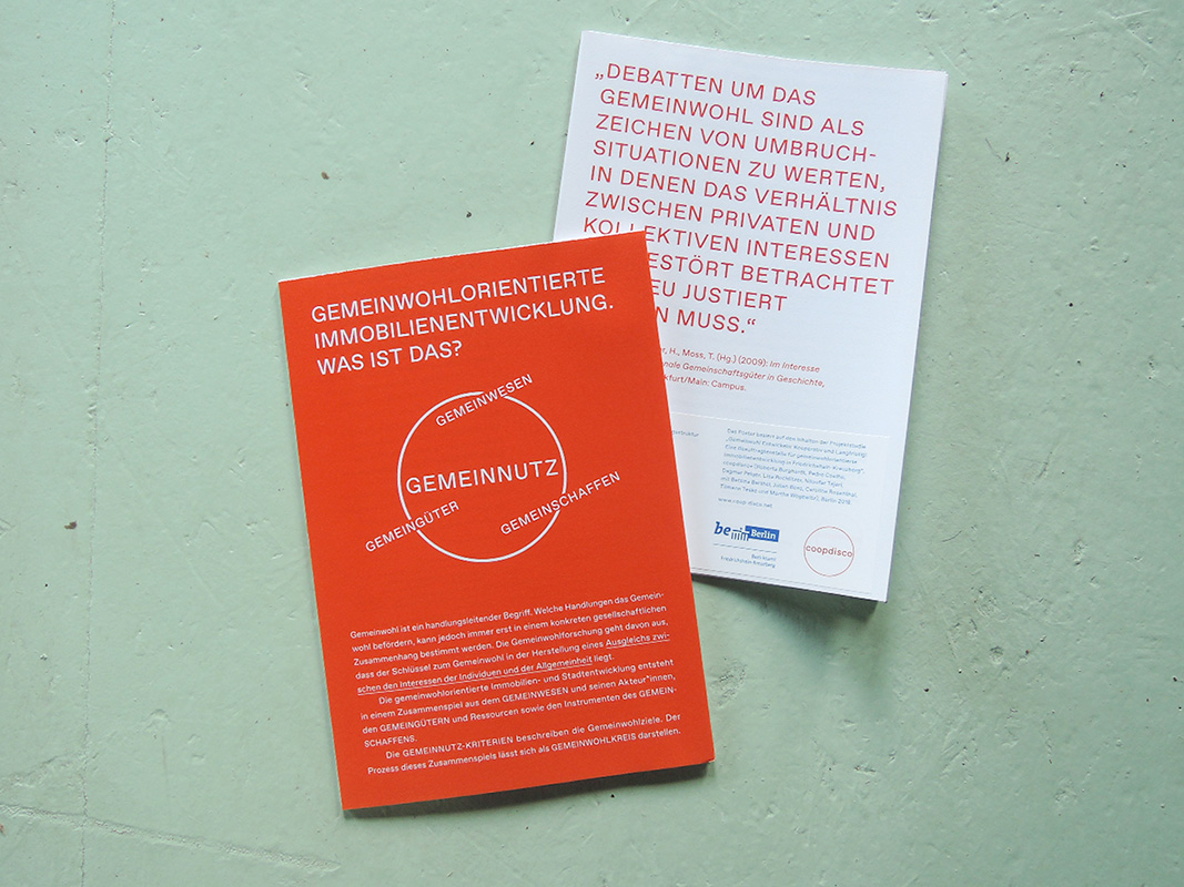
For me, the key lies at what we discussed about the resources. There is this fantastic interview of Stavrides and De Angelis in An Architektur6, where they were also asked about the state: if we want an authority which has the legitimation to protect resources, then I wonder how it should work… Coopdisco made a study for the borough of Friedrichshain-Kreuzberg called ‘Gemeinwohlorientierte Immobilienentwicklung’ (common good-oriented real estate development). What we tried to do was to combine the idea of common good, ‘Gemeinwohl’, and the idea of the commons. So far, Gemeinwohl, in the German political discourse, seems to be something which the state guarantees. Within the commons, there is the idea embedded that all the people who are part of the Gemeinwesen – the commoners – contribute to the Gemeinwohl – the common good, for which they need tools of commoning – Instrumente des Gemeinschaffens. In the study, ‘Gemeinwohl entwickeln: langfristig und kooperativ’, the idea is brought forward, that the organised civil society has to ‘force’ the state to work together with them – combining the self-organisation of emancipatory urban political movements and communal authorities, in order to have a continuation of the securement of resources and the commoning around them, the actual daily cultivation. This would have large consequences for urban planning: it would mean that the planning departments and governments would have to open up to the users, to the society – not just offering participatory workshops where options are being presented, but truly opening up for cooperation. Likewise, the users of this Gemeinwesen, us all, would have to organise ourselves in such a way that we can include our visions into planning and thinking. I think this is a big challenge, but it’s already starting. What you said previously about the resources: yes, we have to reclaim the words and the terms and the notions, but I think we also have to reclaim the idea of what the state is or should be.
The power structure you just described is interesting – if it is the citizens asking the state to cooperate, and not the other way around; with these concepts like Big Society, when the state withdraws and just tells people to do what the state might be supposed to be doing.
Yep, on ‘Augenhöhe’ – same eye level!
Exactly! I was wondering how the current crisis might affect, next to the green spaces we talked about, living, working, and getting together in its aftermath. Do you think a different understanding of space might evolve, as a common resource rather than a commodity on the market, also considering the difficulties many have right now to pay their rents, revealing the vulnerability of everyone involved?
It’s a huge question, everybody is speculating right now. Latour was saying that the crisis brings us to preparing for the actual climate crisis7 – so, there are big theories out there. I am afraid I don’t have a big theory, but I think it is obvious that the crisis exactly brings up the questions of commoning or not commoning, questions of our Daseinsvorsorge. That’s exactly the question, what that actually is and who should take care of it, and the old doubts returned that neither the state nor the market can deal with it – but the commons could, maybe, yes! I mean, you could call what is happening now in hospitals more or less self-organisation. The state is also doing a lot, but there is a lot of commoning happening, among neighbours, among school teachers, among care workers and so on. The whole idea of social distancing as an unselfish act of solidarity is quite interesting to observe.
But, what we didn’t talk about yet, but what became really important in my research about the commons, was to understand better that economists see four types of goods, not only three. Elinor Ostrom has built up, together with Vincent Ostrom in the 70s already, a matrix of four types of goods: public goods and private goods, common goods, and club goods. It took me very long to understand how to transfer this economic view on goods to an architectural or urban view on space. I think what is not being discussed enough is that we have public and private spaces – I am sitting here in the private space of my apartment, my Daseinsvorsorge is in the public park outside to compensate for the lockdown limitations; and then I need a common space which I share, for example, within a digital meeting. The local shop owners shape a common space, because it’s open, it’s inclusive, it’s locally embedded – it shares its values with the neighbourhood. But, there is that fourth type of space, the club space. I think what we see here is an emergence. Club space should be more visible, the spaces of the banks, the spaces of the big transnational corporations, the exclusive collective realms, affordable only to a few, and so on. I don’t consider Karstadt owned by René Benko, or the juridical entity of his, a private property – it is club property, as many other stockholders have a share in it. Those four types of ownership and space need to be discussed much more. For me, the idea of privatisation is not sufficient any more to describe the complexities we are becoming aware of now, especially in a crisis where the urban open spaces as a resource become scarce. So I think the commons are one thing which will be strengthened through the crisis – but the clubs as well, for sure.
Could you describe club space in more detail?
In the commons theory, common spaces are inclusive, thus open. Stavrides describes this very well8: they are open, but they are also protective. They are different to public spaces because public space is organised by authority, whereas common spaces are self-organised and determined by the commoners. Private spaces are closed spaces and self-determined through the private individuals. The fourth type, club spaces, are closed and not inclusive – exclusive like private spaces, but with a joint use, as there is a group of users who come together in the club space. But those who come together in the club space have no possibility to determine the rules, and that’s different to common space. For Elinor Ostrom, private TV is a club good, I think the shopping mall is a club space.
Kind of like a gated community…
Exactly. In the beginning, when I started researching, I was also confronted with the students with the question: is a gated community a commons? And I was like nonono, but they were like, why? It fits the definitions. It took me some time to find the argument: no, it’s a club, and this definition of the club is not well-established in the discourse, I think.
Last but not least, let’s talk about tools. You were talking about cartography and mapping a lot, and were using speculative cartography in the Spatial Commons research project. I was wondering if you could explain what that entails and if there are other tools which you find useful for working with urban commons?
For me, cartography or different mapping techniques are the primary choice to analyse urban space production. I consider it a very important tool because it makes it possible to overlay the different aspects of commoning: the physical surroundings, the territory, the places on which it happens; but also, you are able to introduce the action layer on the map. We even did some experiments including information on rules, codes, conventions, and values of commoning, you can even inscribe those into maps, localise them, and find ways to describe the spatial systems which they create.
You were pointing out speculative cartography in particular, which shows the jump into the future. For me as a trained designer, that’s the whole motivation of everything. I learned to do analyses with the idea of a critical transformation. The design approach is always an approach to reshape the given situation into something better. If you take it very positivistic, you just follow the brief of the commissioner; if you have more emancipatory goals in your practice, if you think about the goals that society has, what are the norms, what do we want to fulfil, what do we want to achieve and how all of these things could happen, speculation is the major tool for the designer. You take the given, you look at the history, where it comes from, all the inscriptions and memories in space and try to project them into a wishful future, which is always a speculation since we don’t know what the future will bring. For me, the speculative cartography makes the link or the hinge between cartography as an inventorying search for what there is and a more projective search for what there should be tomorrow, in the future. And that’s why for me, the speculative aspect in cartography is always embedded, whatever you draw – if you draw the situation where my mobile is laying right now, the way I draw it is already a speculation of what I think this mobile should be tomorrow. You can’t get out of this, the speculation is always there, it’s just a question of how to make it visible.
Nice closing words – thanks for the interview, Dagmar!
Footnotes:
1More info: http://www.cud.tu-berlin.de
2More info: http://www.coop-disco.net
3A local neighbourhood initiative which was founded against the displacement of the grocery “Bizim Bakkal” located in Wrangelstrasse, in 2015
4Which can be found here: https://depositonce.tu-berlin.de/bitstream/11303/7521/5/SC_atlas_orte.pdf
5Further reading: https://en.wikipedia.org/wiki/Common-pool_resource
6The interview can be found here: https://www.e-flux.com/journal/17/67351/on-the-commons-a-public-interview-with-massimo-de-angelis-and-stavros-stavrides/
7Latour’s article can be found here: http://www.bruno-latour.fr/sites/default/files/downloads/P-202-AOC-ROSEN-ALLEMAND_0.pdf.
8See, for example, Stavrides’ book ‘Common Space: The City as Commons’ (2016), London: Zed Books.